spacer
Updated: @ 05-Jul-2026 8:22am - next update at 12:00am  
Summary / Temperature Wind Rain Outlook
Dry Dry
Currently: 82.0, Max: 82.9, Min: 71.2 82.0°F
Warmer 5.5°F than last hour.

---

Feels like: 86°F

24-hr difference
-4°FColder 4.0°F than yesterday at this time.
  Today Yesterday
High: 82.9°F
3:28am
102.7°F
4:43pm
Low: 71.2°F
5:29am
77.0°F
6:48am
 Wind from SSW SSW
1.1
Gust:
3.6 mph
Light Air
Today: 16.3 mph 3:27am
Gust Month: 16.3 mph July 5
Rain Today: 0.00 in
Rain Rate (/hr): 0.000 in
Rain Yesterday: 0.00 in
Storm Rain: 0.00 in
This Month: 0.00 in
Season Total: 20.29 in
15 days since last rain.
Tonight

Thunder storm
Thunder storm
Humidity & Barometer Almanac Moon
Humidity: 70 % Decreased 5.0% since last hour.
Dew Point: 71.2°F Increased 3.3°F since last hour.
Barometer: 29.970 inHg Falling 0.01  inHg/hr
Baro Trend: Steady
Sunrise: 6:27am
Sunset: 8:42pm
Moonrise: 11:46pm
Moonset: 11:37am
Waning Gibbous
Waning Gibbous, Moon at 19 days in cycle
73%
Illuminated
UV Index Solar Radiation
   1.0     Low 
High: 1.0 @ 7:51am
164 W/m2 (56 %)
High: 175 @  8:11am
 NWS Weather Forecast  -   Today's and Tonight's Outlook
Today

Thunder storm
Thunder storm
Hi >95°F
NWS forecast: Partly sunny. A 40 percent chance of showers and thunderstorms this afternoon. Hot with highs in the upper 90s. Southwest winds around 5 mph, becoming southeast this afternoon.
Tonight

Thunder storm
Thunder storm
Lo ≈75°F
NWS forecast: Mostly cloudy with a 40 percent chance of showers and thunderstorms in the evening, then partly cloudy after midnight. Lows in the mid 70s. Southeast winds around 5 mph, becoming north after midnight.
Click for Full Forecast
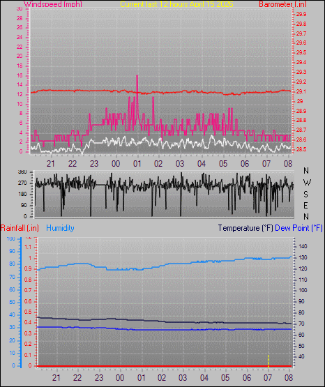
Burleson (Johnson County) Texas - 12 Hour Chart
WD Chart
Plantation
spacer
© 2026, neuba.com | Weather-Display (10.37S-(b151))

Never base important decisions on this or any weather information obtained from
Personal Weather Stations.